The next morning we got up early for a full day of sightseeing. In fact the sun was just touching the top of the mountain when we finished breakfast.
We passed this little farmer's market on the street corner as we headed out of town.
The scenery on the way to the mountain was spectacular. This area is part of a protected scenic area so they control development very tightly.
We were reminded of the interior of the south island in New Zealand - big mountains but a little dry.
This is the jumping off point for the cable car ride to the top of the mountain. It is a multi-step process - you get off your tour bus and take a special bus to the cable car station. I think they do that to keep control of the buses on the narrow, steep roads to the station. Some of the tour buses may have trouble negotiating the turns or the steep sections.
This is a shot out the window of the cable car. It is a pretty long ride. The elevation change on the cable car is about 3800 feet.
Click to enlarge.
Margot is posing at the cable car station at the top.
Note that this is meters NOT feet. That converts to over 14,800 feet. That's higher than any mountain in the lower 48. The top of the mountain is 18,360 feet.
Click to see what Margot is holding in her hand.
It is a little bottle of compressed oxygen. You can take a little huff whenever you feel light-headed. For me that was the second I stood up to get off the cable car.
We chose not to climb up another couple of hundred meters of stairs.
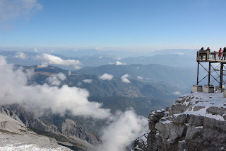
This is view of the surrounding countryside from the top of the mountain.

This is a picture of one of the glaciers near the top. No need to click - it isn't that interesting. I include it just for completeness.
I took this from the cable car on the way down. I thought the light was nice.


No comments:
Post a Comment